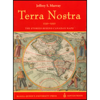
Terra Nostra : the stories behind Canada's maps, 1550-1950 / [by] Jeffrey S. Murray; Published jointly by les éditions Septrion in co-operation with Library and Archives Canada, and Public Works and Government...: SB4-3/2006E

This coffee table book traces 400 years of Canada’s history through the maps that recorded it before satellite imaging and geographic information systems. It also follows the history of map-making, from woodblock printing to lithography, copperplate engraving, offset printing, and, on the battlefield, sun printing using blueprints. The book tells of the people who made the maps and stories behind the maps. It also celebrates Canadian surveying and mapping ingenuity in the face of the country’s almost insurmountable landscape.
Permanent link to this Catalogue record:
publications.gc.ca/pub?id=9.649748&sl=0
| Department/Agency | Library and Archives Canada. |
|---|---|
| Collaborating author | Public Works and Government Services Canada. |
| Title | Terra Nostra : the stories behind Canada's maps, 1550-1950 / [by] Jeffrey S. Murray; Published jointly by les éditions Septrion in co-operation with Library and Archives Canada, and Public Works and Government Services Canada. |
| Publication type | Monograph |
| Language | [English] |
| Other language editions | [French] |
| Format | Paper |
| Other formats | Electronic-[English] |
| Note(s) | "From the collection of Library and Archives Canada". |
| Publishing information | Sillery - Quebec : Library and Archives Canada 2006. |
| Binding | Hardcover |
| Description | 189, [1]p. : coloured illus., coloured maps, photographs ; 31 cm. |
| ISBN | 0-660-19496-1 |
| Catalogue number |
|
| Subject terms | Maps |
Request alternate formats
To request an alternate format of a publication, complete the Government of Canada Publications email form. Use the form’s “question or comment” field to specify the requested publication.- Date modified: